 |
| Those continent colors do seem kind of familiar... |
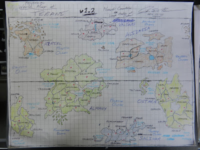
Sixty-three countries scattered across six continents, separated around the world by six oceans. (There is no "six" motif; this was pure coincidence.) For those of you wanting to gaze at this map, you're in luck - the photo is at its default 4000x3000 pixel size because I didn't have the heart to shrink it.
Anyway, I'll let you gaze in wonder. But for those of you who're confused, here's a brief legend:
Names in Pen: Continent (Blue) / Country (Black)Interesting, huh? Well, we'll see where this leads.
Names in Blue Colored Pencil: Ocean
Names in Sky-Blue Colored Pencil: Minor Body of Water
Red Dots: Capital City Location

No comments:
Post a Comment